


Satellite-ASIGN
Satellite-ASIGN açıklaması
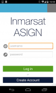
Satellite-ASIGN is an experimental version of UN-ASIGN for crowdsourcing geo-referenced photos, text and disaster needs forms via satellite communications. The intention is to share the data for free with the international humanitarian disaster management community, United Nations, Civil Protection.
Using this App, the communication cost over satellite would not need to be covered by the users of the App. General rights to the photos belong to the users, but Inmarsat is given the rights to share with users and organisations related to this cause. Specifically the observations will be offered to the UN, for integration into live satellite maps.
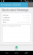
Satellite-ASIGN offers interactive mission-critical visual communications capabilities with geo- and time-tagged photos, where users first send a small preview of a photo, that can be assessed for operational relevance. If and as needed, selected content can later be interactively fetched from the original photos contained within the App.
Uydu asign uydu iletişimi yoluyla jeo-referanslı fotoğraf, metin ve afet ihtiyaçları formları kitle kaynaklı BM-asign deneysel bir sürümüdür. niyet uluslararası insancıl afet yönetim topluluk, Birleşmiş Milletler, Sivil Koruma ile ücretsiz veri paylaşmaktır.
Bu App kullanarak, uydu üzerinden iletişim maliyeti App kullanıcıları tarafından ele alınacak gerek olmazdı. Fotoğraflara genel haklar kullanıcılara aittir, ancak Inmarsat bu uğurda ilgili kullanıcı ve kuruluşlarla paylaşmak için hakları verilir. Özellikle gözlemler canlı uydu haritaları entegrasyon için, BM'ye sunulacak.
Uydu asign operasyonel alaka için değerlendirilebilir kullanıcılar ilk fotoğrafın küçük bir önizleme göndermek coğrafi ve zaman etiketli fotoğraflar, interaktif kritik görev görsel iletişim yetenekleri sunuyor. Eğer gerektiği gibi, seçili içeriği daha sonra App içinde bulunan orijinal fotoğraflardan etkileşimli getirilen olabilir.
Satellite-ASIGN - Sürüm 1.2.6
(10-06-2023)Satellite-ASIGN - APK Bilgisi
APK sürümü: 1.2.6Paket: ansur.asign.inmarsatSatellite-ASIGN uygulamasının en son sürümü
Diğer sürümler


Aynı kategorideki uygulamalar
 4.484.274.334.24


